Expected Dubuque Area Snow Total Friday-Saturday, 01-14-15, 2022
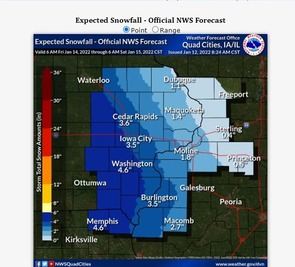
NWS models show snow likely, but major accumulations should stay to our west.
We're fortunate at WJOD to work with Werathertime meterologist Karl Klopotik. Karl's many years of accurate, reliable forecasts have earned a great deal of trust for him and what he says about our weather picture. The expected snow for our area for this Friday and Saturday seems to have people excited, at least judging from my messages and various social media posts I've seen. One person who left a voice message for me insisted that 6-10 inches of snow was coming, and we'd better check our forecast.
It's still early -- let me emphasize, I'm writing this on WEDNESDAY MORNING -- and a lot could change, but Karl is saying our snowfall total for Friday into Saturday should be up to an inch or so. Karl's not the only meterologist seeing it that way, either. Our weather partners at KWWL say that so far, the heaveier snow amounts should be in west-central and western Iowa, and The National Weather Service says less than a half inch is expected on Friday, with up to an inch following that on Saturday.
I'm guessing people are hearing the larger snow total numbers expected for more western parts of the state, including some in the western parts of the coverage area of Waterloo and Cedar Rapids TV stations, and assuming the forecast they heard includes us. Weater is a difficult thing to predict, especially when attempting to pin down a specific number, but so far, the experts all seem to be calling for around an inch of snow for the Dubuque area.
RELATED: 9 More Snows of an inch or more expectd for Dubuque area
READ ON: See the States Where People Live the Longest
More From 103.3 WJOD


![Kane Brown’s Daughter Kingsley Is the Cutest Little Georgia Bulldogs Cheerleader [Picture]](http://townsquare.media/site/204/files/2022/01/attachment-Kingsley.jpg?w=980&q=75)

![Walker Hayes Had to Remix His Song ‘AA’ After Losing National Championship Bet [Watch]](http://townsquare.media/site/204/files/2022/01/attachment-Walker-Hayes.jpg?w=980&q=75)


